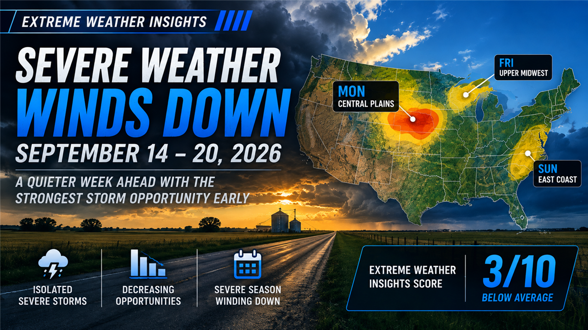
Severe weather season is beginning to wind down across the country, and this week’s forecast reflects that transition.
For September 14–20, 2026, Dr. Gensini gives the week an Extreme Weather Insights Score of 3/10. Only a couple of days currently show a meaningful opportunity for severe weather, with the strongest setup concentrated across the Central Plains to begin the week.
For roofing and exterior contractors, the takeaway is straightforward: Monday provides the clearest storm opportunity, while the remainder of the week becomes increasingly marginal.
Last Week: A Quieter Week Than Forecast
Last week entered with an Extreme Weather Insights Score of 6/10, with the primary severe-weather focus across the Great Plains and a couple of potential opportunities farther east.
Actual activity came in lower than expected.
Damaging wind reports were scattered across much of the country, while most of the hail remained concentrated in the Great Plains. Dr. Gensini ultimately characterized the week as closer to a 3/10 or slightly 4/10, meaning the original 6/10 outlook was somewhat overdone.
One unusual event did stand out: another tornado was reported in Illinois. The state has now recorded more than 215 tornadoes this year, putting it within reach of the all-time state record of 238 held by Texas.
The 2026 Trend Continues: Above-Average Wind, Below-Average Hail
Last week’s quieter activity did little to change the broader severe-weather trends for 2026.
Damaging wind remains above average, while hail continues to track toward finishing the year below normal.
With formal severe-weather season nearing its end, there are fewer opportunities remaining for those trends to change significantly.
Monday: The Week’s Best Severe Weather Opportunity
Monday provides the most notable severe-weather setup of the week.
A large cluster of thunderstorms is moving through western Iowa, primarily producing heavy rainfall with the possibility of damaging winds.
The more interesting setup develops later in the day across eastern Nebraska and western Iowa. As the morning storms move out, additional heating could allow the atmosphere to recharge and support another round of strong to severe thunderstorms.
A tornado is possible, but large hail and damaging winds are the more likely threats.
The primary corridor extends through:
Western Iowa
Eastern Nebraska
North-central Kansas
Des Moines
Omaha
Lincoln
Sioux Falls
These markets represent the strongest severe-weather opportunity of the week.
Tuesday: Storm Threat Pushes South and East
By Tuesday, the storm system shifts farther south and east.
The atmospheric ingredients are expected to be much more marginal, but several major markets remain within the severe-weather opportunity zone.
Areas to monitor include St. Louis, Kansas City, Wichita and Tulsa.
Compared with Monday, however, the environment appears less supportive of significant severe weather.
Wednesday and Thursday: A Much Quieter Pattern
The middle of the week looks quiet.
Cooler conditions spread across much of the northern tier of the country, limiting the ingredients necessary for organized severe thunderstorms.
Heavy rainstorms will still be possible, but significant severe weather is not expected Wednesday or Thursday.
For contractors monitoring hail and wind opportunities, these currently look like the least active days of the forecast.
Friday: A Marginal Upper Midwest Opportunity
Another system begins moving in from the west Friday, bringing primarily heavy rainfall.
There may be enough favorable ingredients for some severe weather across the Upper Midwest, particularly around the Siouxland area, northern Iowa, western Wisconsin and southern Minnesota.
This remains a marginal setup rather than a high-confidence severe-weather event.
Weekend: Low-Confidence Threat Shifts East
The system continues moving east Saturday, with similarly marginal severe-weather ingredients.
By Sunday, lingering remnants could reach the Washington, D.C. area and other portions of the eastern United States.
Exactly how the system evolves from Friday through the weekend remains uncertain. At this point, the ingredients continue to look marginal, making this a forecast worth monitoring rather than a significant storm opportunity to anticipate.
What Roofing Contractors Should Watch This Week
With a 3/10 Extreme Weather Insights Score, there are fewer opportunities than we’ve seen through much of the season.
The key areas to monitor are:
Monday: Eastern Nebraska, western Iowa and north-central Kansas — the strongest opportunity of the week, with large hail and damaging winds the primary threats.
Tuesday: St. Louis, Kansas City, Wichita and Tulsa remain within a more marginal severe-weather corridor.
Wednesday–Thursday: Little significant severe weather expected.
Friday: Northern Iowa, Siouxland, western Wisconsin and southern Minnesota could see isolated severe activity.
Saturday–Sunday: A marginal system progresses east, potentially reaching the D.C. region Sunday.
The biggest immediate opportunity is clearly Monday’s Central Plains corridor. After that, forecast confidence and severe-weather ingredients decrease considerably.
Severe Weather Season Is Approaching the Finish Line
This week also marks a broader transition in the Extreme Weather Insights forecast.
Only a couple of weeks remain in PSAI’s formal severe-weather season, which concludes October 1. Current conditions suggest the country may be moving into a quieter late-September pattern and potentially toward the end of the bulk of 2026’s severe-weather activity.
That doesn’t mean storm opportunities disappear entirely. It means they become more isolated — and identifying exactly where meaningful weather occurs becomes increasingly important.
From Forecast to Action
As severe-weather opportunities become less widespread, contractors have even more reason to focus on actual storm impact rather than broad geographic assumptions.
PSAI Extreme Weather Intelligence helps roofing and exterior contractors track hail and wind events, identify potentially impacted neighborhoods and turn weather intelligence into targeted homeowner audiences.
Monitor the storm → Identify impacted areas → Prioritize opportunity → Build an audience → Activate targeted outreach
During an active spring pattern, there may be storm opportunities across multiple markets simultaneously. In a quieter late-season pattern like this week, the advantage is being able to identify the smaller number of areas where meaningful weather actually occurs — and focus resources there.
Bottom Line
The September 14–20 Extreme Weather Insights Score is 3/10, signaling a much quieter week as the 2026 severe-weather season begins winding down.
The best opportunity arrives immediately, with large hail and damaging winds possible Monday across eastern Nebraska, western Iowa and north-central Kansas. Tuesday brings a more marginal threat farther south and east before conditions become relatively quiet Wednesday and Thursday.
There may be additional opportunities across the Upper Midwest Friday and farther east over the weekend, but confidence remains low.
For contractors, this is a week to be selective rather than broad: watch Monday’s Central Plains storms closely, follow actual storm impacts, and focus outreach where the weather provides a real reason to act.



Subscribe to Predictive Sales AI, LLC's Blog

Comments